Entry 2 – 2023 – February - South Australia.
We continued with our Yorke Peninsula get away. We seem to be returning again and again, year after year, to some of our favourite spectacular scenery locations. We never seemly to tire from its bush settings surrounded by beautiful rugged high energy coastlines. It is a special feeling when you tickle all your well-being senses.
Our last couple of days at Dhilba Guuranda-Innes National Park the weather forecaster had predicted for very strong winds. In other words, it blew a bloody gale. The ocean was covered with white capped peaks as far as the eye could see. It was uncomfortable to be outside with difficulty just standing up in the strong winds.

The new revamped Stenhouse Bay campground had been completed. We remember our utter disappointment with the authorities many years prior with the revamp of the Pondalowie Bay campground. They had set it up with around 50 individual sites but had neglected to consider the popularity of caravans. Most of these sites could only be utilized by smallish tents. There were only 9 caravan sites allocated, hampered in size, restrictive to enter and there have been no improvements.
Thankfully the new Stenhouse Bay campground with around 30 sites had been laid out in a manner all campgrounds and caravan parks should be. The bays were generous with easy access for the driver to monitor while reversing into the site, able to easily view the caravan’s position into the site from the driver’s window.
The travelling tourists were already showing their appreciation with a high percentage of sites in use. This was in contrast to the larger Pondalowie Bay campground with about 5 of its 50 sites in use this same day. The 5 consisted of 3 caravans and 2 tents. Though we prefer the Pondalowie Bay campground due to its closer proximity for access to many of the more popular locations. Still Stenhouse Bay was only 14 kilometres from “Pondie.”
We also stopped to view the powerful ocean waves at different locations in the national park. The wind was beating up a large swell, creating a lot of white water. It was an awesome sight.
We were aware of the requirement to keep our vehicle speed down around the national park for the safety of everyone. At one stage Mary was in need to slam the vehicle brakes on when an emu sprinted out from behind some bushes directly into our passage. We did appreciate the burst of speed an emu can obtain. Any other animal and it would have been “contact!”

Even walking along the pathways in the campground we regularly had the need to give way to wandering emus. At times an emu would grunt loudly at us showing their disapproval of our presence and our heart rate would increase looking up into their eyes. It all added to the excitement of the delightful Dhilba Guuranda-Innes National Park. It is such a special location.
With the wind continuing to “blow,” our national parks time limitation expired requiring us to move on.
The ferocity of the wind was unsettling and we were undecided where next to best set camp. There were some beautiful bush camps available between Marion Bay and the Corny Point area. We weren’t inclined to set camp where we had to contend with uncomfortable strong wind and additional crowds of people about.
Our favourite camp area along this section was Swincer Rocks campground. It is very open, vulnerable to the ocean winds. We found people don’t stay long due to the unsettling wind factor. There is one site partially protected from the SW ocean winds by a small hump which we have managed to secure most times when we have previously visited.
We decided to have a look at Swincer Rocks feeling nervous with our decision to just have a look. We should not have been surprised to find the campground deserted, not one soul present. We were delighted to secure our favourite camp site. The strength of the wind was the fiercest we had ever experienced at Swincer Rocks and we bunkered down for the day with some appreciated protection from our hump.


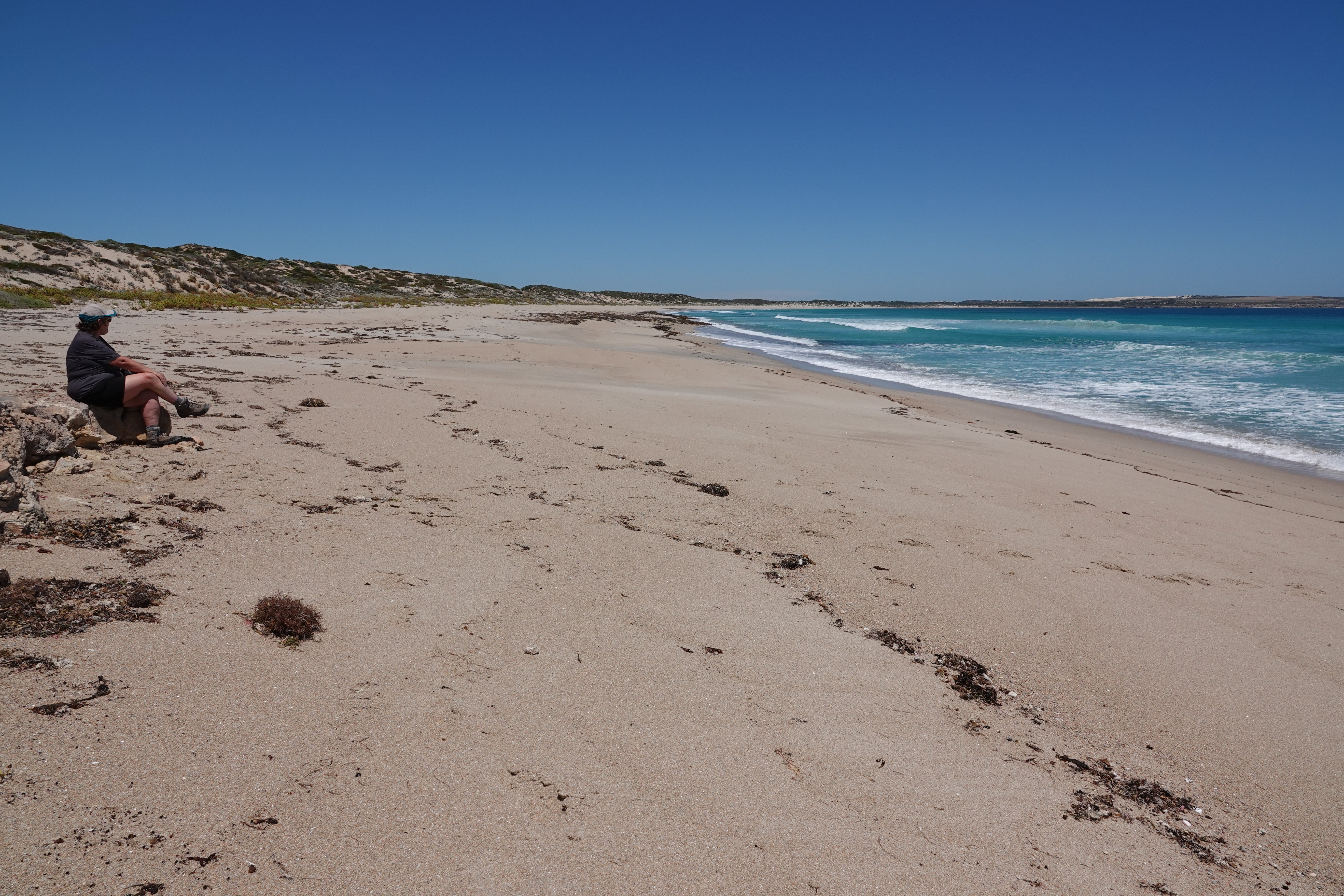
By the following day the gale force winds had abated but it was still quite strong. We appreciated being able to stretch out our legs walking to the other end of Swincer Rocks beach. Our phone app showed we had completed around 4,000 steps at a distance of about 2 kilometres from our camp to the other end of the beach. The sand surface provided us with a good work out, not hard or too soft under our feet.


We have found camping near a beach on Yorke Peninsula to generally be a windy experience. It took another couple of days for the wind to settle to a comfortable level. This included for the swell to abate. Day 4 at Swincer Rocks, the ambient air temperature, combined with more a comfortable wind level and calming seas enticed us into the ocean for a swim. It still felt a bit like we were in a washing machine getting tossed about.

The ocean water was a refreshing chilly temperature. Our dip in the ocean waters finally provided that all over satisfaction, adding to the complete effect of camping at the beach. Not only were the views most satisfying, now our bodies had that crusty dried salt feel about them. Perfect beachside camping.
Mostly we would walk north from our camp site, drawn in by the magnetism of the beautiful beach setting. We did manage to ignore this magnetic field one day, walking in the opposite direction along a rocky cliff top. After about 15 minutes we found ourselves at the end of another beautiful beach, Gleesons Landing. There were even some good-looking surf waves.


We do like the all-round viewing from our caravan windows. When we are at a special scenic location without people about, we often go to bed for the night with our curtains open. Swincer Rocks was one of those fabulous locations. Early one morning we watched the moon reflections dancing on the ocean waters as it disappeared into the ocean depths all from the comfortable position of our bed.

There were many glorious sunsets to view. Some we viewed from our caravan windows and some whilst strolling along the beach for an evening walk.


Once again Swincer Rocks delighted all our good feel senses.


The commencement of 2023 the local council had increased the nightly fee from $10 to $20 per night at the bush camping locations scattered around the lower regions of Yorke Peninsula. This was one of the few campgrounds without any facilities. There were signs where it appeared the council were in the process of constructing a toilet at Swincer rocks. We thought this to be a good thing. Once completed we suspect the volume of campers will increase, diminishing the “wow” factor for us, with most of our previous visits having minimal to often no other people about. The below picture was from our last walk to the other end of “our beach.”

It was time for us to move on. As an added incentive, strong winds returned to “our bit of paradise,” acting like a crow bar, helping to lever us away. Just up the road a bit we propped at Berry Bay, another great beach location Steve had fond memories from his younger days. There was a school group utilizing the beach for some aquatic’s activities. We were already missing our near deserted Swincer Rocks beach.

Around the 75 kilometre mark up the road we propped at the town of Minlaton, time for a cuppa. We knocked on the door of another couple whom we met whilst out and about in our caravan. There was lots of chatter. We ended up having our evening meal together at a local café’. We camped the night in their driveway leaving after breakfast. More good times with Rob and Glenda.

Yorke Peninsula primarily comprises of agricultural land. Travelling about we spend some of our time observing the paddocks guessing what type of crop had been sown. Then there are the agriculture road hazards to be mindful of.


It was around a 3-hour drive to our home. We were feeling a little bit sad to be leaving Yorke Peninsula and on a spur of the moment thing drove into the town of Ardrossan. There was a nice free camp location nearby the centre of town and we thought we would stay for a bit if a site was available. To our surprise and delight we parked up in a free site. Ten minutes later we were walking along the main street, looking at the op shop, bakery and general sights. It was then into the supermarket where we obtained some food to replenish some of our evaporated basic supplies. We were instantly in a much happier mood, adding another night spent on Yorke Peninsula.


We had a good get away enjoying the great Australian outdoors. It certainly provided a much-appreciated boost to our well-being. It was still early times in the new year with a need to return to our home base. We were in the final process of planning out our 2023 activities. Part of this involves managing a couple of weeks of medical appointments, hopefully addressing our personal maintenance needs, where we can do whatever, whenever we want for the rest of the year. In the mix we had a duty of care to our tow tug with a service booked. And we had a growing list of things to do prior clearance for departure.


